ROAD DESIGN AND TECHNOLOGY

Design Controlling Factors in Geometry Highway Design

Design controlling factors in geometry highway design determine how safely and efficiently vehicles move through our road networks. Every curve, gradient, and lane width you encounter on a highway exists because engineers carefully balanced eight critical factors during the design phase. These decisions affect everything from your daily commute to multi-billion dollar infrastructure investments.

Think about the last time you drove on a winding mountain road versus a straight interstate highway. The dramatic difference in their geometry isn't random—it's the result of systematic analysis of controlling factors that shape every meter of pavement. Understanding these factors helps construction professionals create highways that serve communities for decades while protecting lives and environmental resources.

Understanding Geometric Highway Design

Geometric highway design involves creating the three-dimensional layout of roadways through careful planning of alignment, profile, and cross-section. The alignment defines the route as a series of horizontal tangents and curves, while the profile establishes vertical alignment, and the cross-section determines the roadway’s perpendicular dimensions. These three components work together to create the physical form drivers experience.

The geometry you see on highways directly impacts safety, capacity, and user comfort. Poor geometric design increases crash rates, reduces traffic flow, and frustrates drivers. Excellent geometric design feels intuitive—drivers naturally maintain appropriate speeds without constant braking or acceleration.

Unlike structural design, which focuses on how roads carry loads without failure, geometric design addresses how roads guide vehicle movement. While structural engineers calculate pavement thickness and bridge capacity, geometric designers determine curve radii, sight distances, and lane widths. Both disciplines intersect in creating functional infrastructure, but their primary concerns differ fundamentally.

How Does Geometric Design Differ from Structural Design?

Structural design ensures roads physically support traffic loads through proper material specifications and pavement depth calculations. Geometric design ensures roads accommodate traffic movement through appropriate horizontal curves, vertical grades, and cross-sectional elements. A structurally sound road with poor geometry remains dangerous and inefficient despite its load-bearing capacity.

How Road Classification Influences Highway Geometry

Road classification serves as the foundation for all geometric design decisions because different road types serve distinct transportation functions. Design guidelines vary for freeways, arterials, collectors, and local roads, in both urban and rural locations, paralleling the functional classification system. Each classification demands specific geometric standards that reflect its intended purpose within the broader transportation network.

Functional Classification Systems

Interstate highways form the backbone of long-distance travel, requiring the highest design standards. They feature controlled access, wide lanes, generous clear zones, and gentle curves to accommodate high-speed traffic safely. Design speeds typically range from 110-130 km/h, with corresponding geometric elements that support these velocities.

Arterial roads balance mobility and access, connecting major activity centers within regions. They handle substantial traffic volumes but permit more access points than interstates. Design speeds generally fall between 80-110 km/h, with geometric standards that reflect this intermediate function.

Collector roads gather traffic from local roads and channel it toward arterials. They feature moderate design speeds (50-80 km/h) and more frequent intersections. Their geometry reflects the transition between local access and regional mobility.

Local roads prioritize property access over mobility, featuring the most relaxed geometric standards. Design speeds rarely exceed 50 km/h, and their layout emphasizes convenience for adjacent land uses rather than through traffic movement.

Design Standards by Classification

The U.S. Department of Transport establishes minimum geometric criteria for each classification. Lane widths vary from 3.0 meters on local roads to 3.6 meters on interstate highways. Shoulder dimensions follow similar patterns, with interstate shoulders reaching 3.0 meters while local roads may feature minimal or no paved shoulders.

Projects on the National Highway System must comply with AASHTO standards, with the Federal Highway Administration adopting the Green Book as the official design reference. This regulatory framework ensures consistency across jurisdictions while permitting flexibility for unique circumstances.

Understanding these classifications matters for construction professionals because they directly influence project costs, schedules, and technical requirements. An interstate reconstruction demands far more rigorous standards than a local road improvement, affecting everything from surveying precision to quality control protocols.

What Determines a Road’s Functional Classification?

Classification depends on the road’s role within the transportation network hierarchy. Factors include traffic volume, trip length, connection to major destinations, and spacing relative to parallel facilities. State transportation departments typically assign classifications based on comprehensive network planning that considers current and projected travel patterns.

Road ClassificationDesign Speed (km/h)Lane Width (m)Shoulder Width (m)Typical ADT Range
Interstate Highway110-1303.63.0-3.6>50,000
Principal Arterial90-1103.3-3.61.8-3.020,000-50,000
Minor Arterial80-1003.3-3.61.2-2.410,000-30,000
Major Collector60-903.0-3.61.2-2.42,000-15,000
Minor Collector50-803.0-3.30.6-1.8500-5,000
Local Road30-602.7-3.30-1.2<2,000

Understanding the relationship between road classification and the details in Kenya Road Design Manual helps construction professionals apply appropriate standards in regional contexts.

Sand Type Price per tonne Price per lorry (18 Tonnes) Best Application
Sand
Ksh. 3,000
Kh. 54,000
Foundation, structural concrete
Black Sand
Ksh. 2,500
Ksh. 45,000
Plastering, general construction
Rock Sand
Ksh. 3000
Ksh. 54,000
Concrete Work and Masonry works
River Sand
Ksh 1,800-2,100
Ksh. 32,000-38,000
Premium finishing, plastering
Quarry Dust
Ksh. 1350
Ksh. 24,500
Backfilling and non-structural work

Level of Service: Measuring Highway Performance

Level of service measures how well a highway facility accommodates traffic demand by quantifying the quality of flow conditions drivers experience. LOS qualitatively relates motor vehicle traffic service quality by categorizing traffic flow and assigning quality levels based on performance measures like vehicle speed, density, and congestion. This concept transforms abstract traffic engineering into tangible service quality metrics that guide design decisions.

Engineers use LOS to evaluate whether proposed geometric designs will adequately serve projected traffic volumes. A highway designed for heavy traffic but experiencing frequent congestion fails its intended purpose regardless of construction quality. LOS analysis ensures geometric elements match anticipated demand.

What is Level of Service?

Level of service represents the operational quality that drivers experience on a highway facility during specific time periods. It considers multiple performance factors including travel speed, freedom to maneuver, traffic interruptions, comfort, and convenience. These factors combine to create an overall assessment of how satisfactorily the facility serves its users.

The concept emerged from recognition that highways operate along a continuum from completely free-flowing to severely congested. Rather than simply labeling conditions as “good” or “bad,” LOS provides six distinct categories (A through F) that describe increasingly restricted operating conditions. This granularity helps designers target specific performance outcomes.

Transportation agencies use LOS extensively for planning, design, and operational analysis. It informs decisions about when to expand capacity, where to implement access management, and how to prioritize limited funding. The metric provides a common language for communicating highway performance to both technical professionals and public stakeholders.

LOS Categories and Their Characteristics

LOS A represents free-flow conditions where drivers experience minimal restrictions. Vehicles travel at or near the free-flow speed (FFS), typically 90% or above. Density remains very low, giving drivers complete freedom to maneuver without interference from other vehicles. This represents ideal operating conditions that many highway users consider “worth paying for” through tolls or other mechanisms.

LOS B maintains stable flow but with slightly more restrictions than LOS A. Travel speeds average around 70% of free-flow speed. Side-friction from other vehicles begins affecting driver behavior, though comfort and convenience remain relatively high. Many agencies target LOS B as their design objective because it balances quality service with reasonable infrastructure costs.

LOS C indicates stable flow with noticeable restrictions on maneuvering freedom. Travel speeds drop to approximately 50% of free-flow speed. Side-friction significantly affects driver comfort, and the ability to change lanes or pass slower vehicles becomes noticeably constrained. Despite these limitations, operations remain generally stable without the stop-and-go patterns characteristic of breakdown conditions.

LOS D approaches unstable flow as volume nears capacity. Small disruptions can cascade into significant delays. Drivers experience substantial restrictions on speed and maneuverability. While still considered acceptable for design purposes in many contexts, especially peak periods in urban areas, this level marks the threshold where minor incidents can trigger major congestion.

LOS E represents operation at or near capacity, where flow becomes unstable. Any disruption causes the facility to fail, triggering breakdown conditions. Speeds vary considerably, and no freedom exists to maneuver. Density reaches the maximum sustainable level before complete breakdown occurs.

LOS F indicates breakdown conditions where demand exceeds capacity. Queues form and grow, with vehicles experiencing stop-and-go waves. This represents failure from a design perspective, though many urban highways experience LOS F during peak periods due to land use patterns and budget constraints that preclude building sufficient capacity.

How LOS Affects Design Decisions

Freeways should be designed to accommodate design year peak hour traffic volumes and operate at a LOS determined by District Planning and/or Traffic Operations. This target LOS directly influences geometric decisions. Achieving LOS B requires more generous lane widths, longer acceleration lanes, and gentler curves than designs targeting LOS D.

The design year typically extends 20-25 years beyond project completion, reflecting the long service life of highway infrastructure. Engineers project traffic volumes for this future year and select geometric elements that will maintain acceptable LOS even as demand grows. This forward-looking approach prevents premature obsolescence.

Peak hour considerations heavily influence design because highways must adequately serve their busiest periods. The design hour volume (DHV) typically represents the 30th highest hour of the year, providing reasonable assurance that the facility will meet user expectations during most peak periods while acknowledging that occasional congestion during extreme peaks may be economically unavoidable.

Volume-to-capacity ratios directly link LOS to geometric design. These ratios compare actual or projected traffic volumes against the theoretical maximum capacity that geometric elements can accommodate. When ratios approach or exceed 1.0, indicating volume matches or surpasses capacity, the facility operates at LOS E or F regardless of geometric quality.

How is LOS Calculated for Different Facility Types?

The Highway Capacity Manual serves as the primary reference for traffic operational analysis, methodologies, and level of service concepts, providing guidelines for evaluating roadway segments and intersections based on extensive operational performance data. Different facility types require different calculation procedures because operational characteristics vary substantially between freeways, multilane highways, two-lane roads, and urban streets.

Freeway LOS calculations emphasize density as the primary service measure, measured in passenger cars per kilometer per lane. The HCM provides detailed procedures that account for geometric characteristics, traffic composition, and driver population factors. These calculations help designers understand how proposed geometric elements will affect operational quality.

Understanding Highway Capacity in Design

Highway capacity represents the maximum sustainable hourly rate at which vehicles can traverse a roadway section under prevailing conditions. This fundamental concept differs from simple lane counting—capacity depends on complex interactions between geometric design, traffic composition, driver behavior, and environmental factors. Understanding capacity enables designers to create highways that efficiently move traffic without chronic congestion.

What Determines Highway Capacity?

Lane configuration profoundly affects capacity. Each standard 3.6-meter lane on a freeway can theoretically accommodate approximately 2,200 passenger cars per hour under ideal conditions. However, adding lanes doesn’t linearly multiply capacity because weaving maneuvers and merge conflicts create turbulence that reduces per-lane throughput. Four-lane facilities don’t carry exactly twice the volume of two-lane facilities.

Vehicle mix significantly impacts capacity because trucks, buses, and recreational vehicles occupy more space and accelerate more slowly than passenger cars. Heavy vehicles reduce capacity through passenger car equivalent (PCE) factors that convert mixed traffic streams into equivalent passenger car volumes. A single truck might have a PCE of 2.0 on level terrain or 5.0 on steep grades, effectively consuming multiple passenger car spaces.

Environmental factors including weather, visibility, and pavement conditions affect capacity by influencing driver behavior. Rain reduces capacity by 10-15% as drivers increase following distances and reduce speeds. Fog, snow, or ice can reduce capacity by 30-50% or more. Designers must consider whether to design for all-weather capacity or accept reduced service during adverse conditions.

Design Hour Volume Considerations

The K-factor represents the proportion of annual average daily traffic (AADT) occurring during the peak hour. Typical K-factors range from 0.08 to 0.15, meaning the peak hour carries 8-15% of daily traffic. Higher K-factors indicate more peaked traffic patterns requiring more capacity relative to daily volumes. Rural recreational routes often exhibit high K-factors as weekend traffic far exceeds weekday volumes.

Directional distribution matters because traffic doesn’t split evenly between opposing directions. Many highways experience 60/40 or 65/35 directional splits during peak hours as commuter traffic flows toward employment centers in the morning and away in the evening. Designers must provide adequate capacity for the heavier direction while potentially accepting reduced service in the lighter direction.

The 30th highest hour concept establishes a reasonable balance between serving peak demand and avoiding massive overinvestment in capacity that sits unused most of the year. By designing for the 30th highest hour rather than the absolute peak, agencies accept that approximately 29 hours annually may experience congestion levels exceeding design targets. This pragmatic approach acknowledges budget constraints while maintaining generally acceptable service.

What’s the Difference Between Capacity and Volume?

Capacity represents the maximum throughput a facility can sustain under specific conditions—it’s a supply measure. Volume represents the actual number of vehicles using the facility during a given period—it’s a demand measure. A highway might have capacity for 4,000 vehicles per hour but only carry 2,000 vehicles per hour during typical midday periods when demand remains low.

Understanding this distinction matters because capacity sets an upper limit on how much traffic a facility can handle, but actual volumes depend on land use patterns, trip generation, and transportation network characteristics beyond the designer’s direct control. Designers provide capacity; travel behavior determines whether that capacity gets fully utilized.

How Topography Controls Highway Geometry

Topography ranks among the most influential design controllers because you cannot easily change the earth’s natural contours. Construction costs increase multifold with gradient and terrain for a given design speed, making geometric design standards different for different terrain types to keep construction costs and time under control. The physical landscape dictates feasible alignment options and drives fundamental trade-offs between geometric standards, construction costs, and environmental impacts.

Terrain Classification

Level terrain exhibits cross slopes between 0-5%, allowing highway construction with minimal earthwork. Designers enjoy maximum flexibility in alignment selection, enabling gentle curves, gradual grades, and optimal sight distances. Construction costs remain relatively low because cut and fill volumes balance efficiently. Many interstate highways traverse level terrain, explaining their characteristically gentle geometry.

Rolling terrain features cross slopes between 5-10%, requiring moderate earthwork to achieve acceptable grades and curves. Designers must carefully balance cut and fill to minimize haul distances and construction costs. Horizontal alignment flexibility decreases as terrain becomes more pronounced, though reasonable design speeds remain achievable with proper planning. Construction costs typically run 1.5-2 times those for level terrain projects of similar length.

Mountainous terrain presents cross slopes exceeding 10%, demanding extensive earthwork, retaining structures, and potentially tunneling to maintain acceptable geometric standards. Design speed often must be reduced below ideal values to keep construction costs feasible. Horizontal curves become sharper, grades steeper, and sight distances more restricted than in flatter terrain. Construction costs can exceed 3-5 times those for level terrain, sometimes reaching 10 times in extreme cases.

Examining how African countries with extensive road networks address diverse topographic challenges provides valuable context for regional infrastructure development strategies.

Design Implications by Terrain Type

Gradient limitations vary dramatically by terrain. Level terrain permits maximum grades of 3-4% on interstate highways, while mountainous terrain may necessitate grades up to 6-7% or even 8% on lower-classification roads. Steeper grades reduce truck speeds, increase crash risk, and raise vehicle operating costs through increased fuel consumption and brake wear.

Horizontal curve requirements tighten as terrain becomes more severe. Level terrain permits very large radius curves (1,000+ meters) that drivers barely notice, while mountainous terrain may require curves as tight as 150-200 meters on major highways. Tighter curves necessitate reduced design speeds, increased superelevation, and enhanced sight distance provisions where possible.

Cut and fill considerations dominate cost estimation in rolling and mountainous terrain. Deep cuts expose unstable soil layers requiring extensive stabilization. High fills risk settlement and slope failures without proper foundation preparation. The Proctor Test helps engineers assess compaction requirements for embankment construction in challenging terrain.

How Does Terrain Affect Design Speed Selection?

Design speed is the most important factor affecting geometric design of highways, influencing sight distances and other critical parameters. Flat terrain permits high design speeds (110-130 km/h for freeways) because gentle curves and grades present minimal obstacles. Rolling terrain typically reduces design speeds to 90-110 km/h as geometric constraints increase. Mountainous terrain may necessitate design speeds of 60-80 km/h where topography severely limits alignment options.

Designers balance competing pressures: users demand high travel speeds for mobility, but terrain constraints make high-speed alignment prohibitively expensive. The solution involves selecting design speeds that provide reasonable mobility while maintaining acceptable construction costs and environmental impacts. This optimization process represents engineering judgment at its finest—no formula provides perfect answers.

Order Construction Materials From Us Today

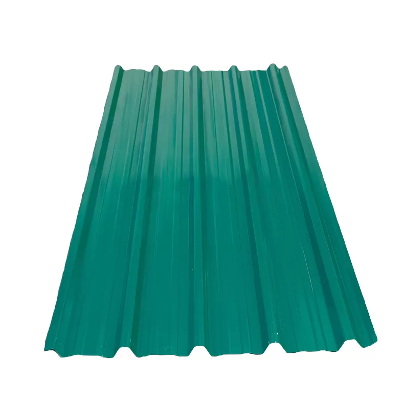
Box Profile (Glossy, Gauge 28)

KSh 650.00
Our Box Profile iron sheets are crafted for superior durability and exceptional weather resistance, making them the ideal choice for long-lasting roofing solutions across Kenya. To make your project even more convenient, we offer free delivery across Kenya when one orders 40 pieces and above. Trust us for reliable products and dependable service for all your building needs.

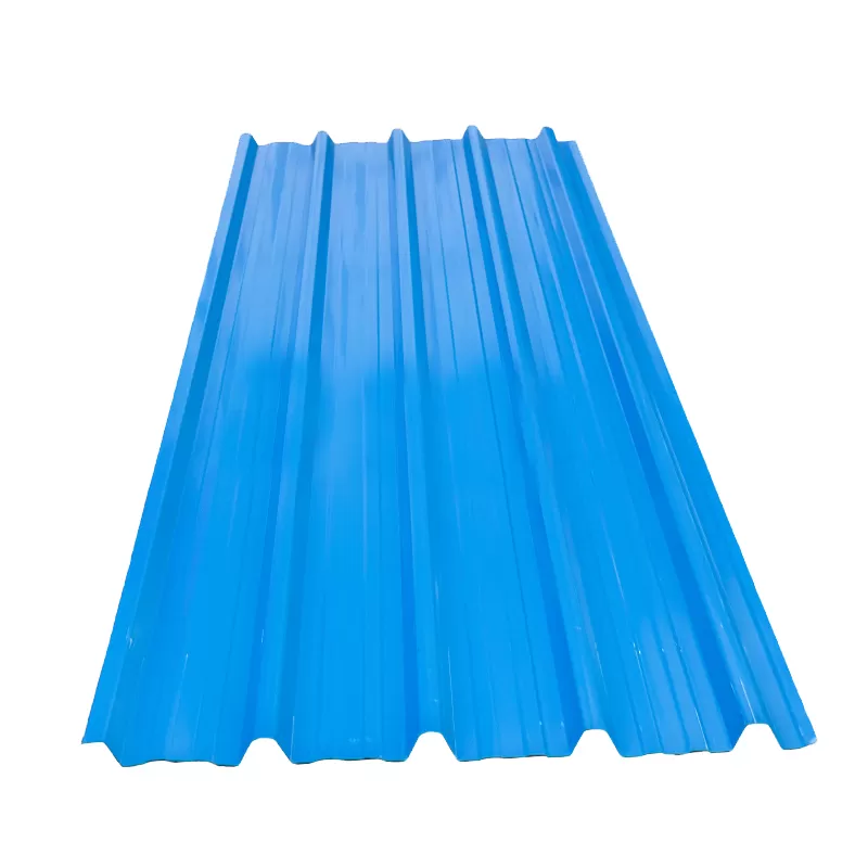
Box Profile (Glossy)

KSh 470.00
Our Box Profile iron sheets are crafted for superior durability and exceptional weather resistance, making them the ideal choice for long-lasting roofing solutions across Kenya. To make your project even more convenient, we offer free delivery across Kenya when one orders 40 pieces and above. Trust us for reliable products and dependable service for all your building needs.

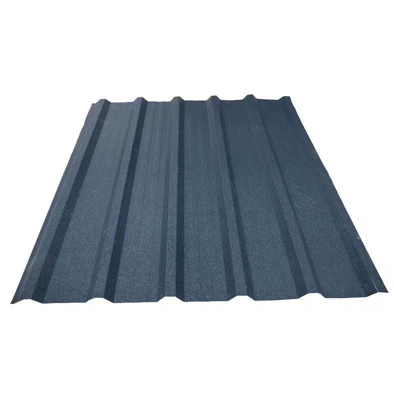
Box Profile (Matte, Gauge 28)

KSh 680.00
Our Box Profile iron sheets are crafted for superior durability and exceptional weather resistance, making them the ideal choice for long-lasting roofing solutions across Kenya. To make your project even more convenient, we offer free delivery across Kenya when one orders 40 pieces and above. Trust us for reliable products and dependable service for all your building needs.

Box Profile (Matte)

KSh 530.00
Our Box Profile iron sheets are crafted for superior durability and exceptional weather resistance, making them the ideal choice for long-lasting roofing solutions across Kenya. To make your project even more convenient, we offer free delivery across Kenya when one orders 40 pieces and above. Trust us for reliable products and dependable service for all your building needs.

Corrugated Iron Sheet (Gauge 30)

KSh 470.00
Our corrugated iron sheets are crafted for superior durability and exceptional weather resistance, making them the ideal choice for long-lasting roofing solutions across Kenya. To make your project even more convenient, we offer free delivery across Kenya when one orders 40 pieces and above. Each high-quality sheet provides excellent value for money, ensuring your structure is protected for years to come. Trust us for reliable products and dependable service for all your building needs.

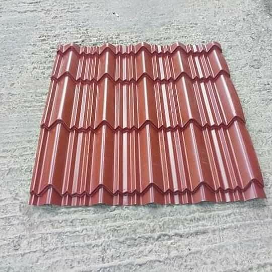
Elegantile (Glossy, Gauge 28)

KSh 670.00
Our Elegant Tile  profile are crafted for superior durability and exceptional weather resistance, making them the ideal choice for long-lasting roofing solutions across Kenya. To make your project even more convenient, we offer free delivery across Kenya when one orders 40 pieces and above. Trust us for reliable products and dependable service for all your building needs.

Elegantile (Glossy, Gauge 30)

KSh 550.00
Our Elegant Tile  profile are crafted for superior durability and exceptional weather resistance, making them the ideal choice for long-lasting roofing solutions across Kenya. To make your project even more convenient, we offer free delivery across Kenya when one orders 40 pieces and above. Trust us for reliable products and dependable service for all your building needs.

Elegantile (Matte, Gauge 28)

KSh 680.00
Our Elegant Tile  profile with matte texture are crafted for superior durability and exceptional weather resistance, making them the ideal choice for long-lasting roofing solutions across Kenya. To make your project even more convenient, we offer free delivery across Kenya when one orders 40 pieces and above. Trust us for reliable products and dependable service for all your building needs.

Elegantile (Matte, Gauge 30)

KSh 580.00
Our Elegant Tile  profile with matte texture are crafted for superior durability and exceptional weather resistance, making them the ideal choice for long-lasting roofing solutions across Kenya. To make your project even more convenient, we offer free delivery across Kenya when one orders 40 pieces and above. Trust us for reliable products and dependable service for all your building needs.

Versatile (Glossy, Gauge 28)

KSh 670.00
Our versatile iron sheets are crafted for superior durability and exceptional weather resistance, making them the ideal choice for long-lasting roofing solutions across Kenya. To make your project even more convenient, we offer free delivery across Kenya when one orders 40 pieces and above. Trust us for reliable products and dependable service for all your building needs.

Versatile (Glossy, Gauge 30)

KSh 550.00
Our versatile iron sheets are crafted for superior durability and exceptional weather resistance, making them the ideal choice for long-lasting roofing solutions across Kenya. To make your project even more convenient, we offer free delivery across Kenya when one orders 40 pieces and above. Trust us for reliable products and dependable service for all your building needs.

Versatile (Matte, Gauge 28)

KSh 680.00
Our versatile iron sheets are crafted for superior durability and exceptional weather resistance, making them the ideal choice for long-lasting roofing solutions across Kenya. To make your project even more convenient, we offer free delivery across Kenya when one orders 40 pieces and above. Trust us for reliable products and dependable service for all your building needs.

Budget Constraints and Design Optimization

Financial considerations profoundly shape geometric highway design because infrastructure projects compete for limited public resources. Every design decision carries cost implications that extend far beyond initial construction. Engineers must balance ideal geometric standards against fiscal realities while ensuring highways remain safe and functional throughout their design life. This constant tension between engineering perfection and economic pragmatism defines modern highway design practice.

Initial Construction Costs

Earthwork expenses typically represent 20-35% of total construction costs on major highway projects. Moving massive quantities of soil and rock demands expensive equipment, fuel, and labor. Mountainous terrain projects can require earthwork costs exceeding 50% of total budgets. Designers minimize these costs by carefully balancing cut and fill volumes, reducing haul distances, and optimizing alignment to follow natural contours where feasible.

Pavement materials constitute another major cost driver, consuming 25-40% of highway budgets. Asphalt concrete costs vary regionally but typically range from $80-150 per ton. Portland cement concrete pavement costs even more but offers extended service life. Material selection involves complex trade-offs between initial expense and long-term performance. Understanding Portland cement types available in the Kenyan market helps designers specify appropriate materials for local conditions.

Drainage systems protect pavement integrity by managing surface and subsurface water. Culverts, catch basins, detention ponds, and pipe networks add 10-15% to project costs. Inadequate drainage severely shortens pavement life, making this investment essential despite the expense. Designers optimize drainage layouts to provide necessary protection while minimizing infrastructure requirements.

Life-Cycle Cost Analysis

Maintenance requirements vary dramatically based on initial design quality. Well-designed highways with appropriate geometric standards require minimal maintenance for 15-20 years beyond construction. Poor designs demand frequent repairs, lane closures, and user inconvenience that multiply total costs over time. Life-cycle cost analysis (LCCA) quantifies these long-term implications to support informed decision-making.

Rehabilitation schedules depend on traffic volumes, climate, and initial construction quality. Major rehabilitation typically occurs every 15-25 years, involving significant expense. Designers can extend these intervals through durable materials, proper drainage, and geometric elements that reduce pavement stress. Each year of extended service life produces substantial cost savings when calculated across entire highway networks.

User costs include vehicle operating expenses, travel time value, and crash costs that highways impose on society. Poor geometric design increases fuel consumption through excessive grades and curves. Congestion from inadequate capacity wastes billions of hours annually. Crashes on substandard roads generate enormous societal costs. Modern design practice increasingly incorporates these user costs into project evaluation alongside direct construction expenses.

How Do Designers Balance Safety and Budget?

Designers employ value engineering to identify cost savings that don’t compromise safety. This systematic review examines alternative materials, construction methods, and design features to optimize value. Safety elements like adequate sight distance, gentle curves, and wide clear zones receive highest priority, with cost reductions sought in less critical areas.

When budgets absolutely prevent meeting ideal standards, designers document design exceptions that formally acknowledge deviations from criteria. These exceptions require thorough safety analysis and approval from appropriate authorities. The process ensures informed decision-making about risk acceptance rather than inadvertent safety compromises.

Safety Considerations in Geometric Design

Safety stands as the paramount concern in highway geometric design because roadways directly influence crash occurrence and severity. The geometric design process defines infrastructure location and dimensions that either prevent crashes or make them more survivable. Every geometric element, from curve radius to shoulder width, affects the likelihood and consequences of driver errors. Designers who understand these safety relationships create highways that forgive inevitable human mistakes rather than punish them with crashes.

Design Elements That Enhance Safety

Stopping sight distance provides the minimum visible roadway length needed for drivers to perceive hazards, react, and brake before collision. This critical design element depends on driver perception-reaction time (typically 2.5 seconds), vehicle braking capability, and roadway grade. Insufficient sight distance forces drivers into emergency maneuvers or crashes. AASHTO standards specify minimum stopping sight distances ranging from 85 meters at 50 km/h design speed to 305 meters at 130 km/h.

Passing sight distance applies to two-lane highways where drivers must see far enough ahead to complete overtaking maneuvers safely. These distances substantially exceed stopping sight distance—a highway with 160 meters of stopping sight distance requires 345 meters of passing sight distance at 80 km/h design speed. Designers provide passing zones where sight distance permits safe overtaking and use pavement markings to prohibit passing where sight distance proves inadequate.

Decision sight distance gives drivers time to process complex information at locations requiring unusual maneuvers. Interchanges, lane drops, and unexpected geometric changes need more sight distance than simple tangent sections. Decision sight distance requirements range from 1.5 to 4 times stopping sight distance, depending on maneuver complexity. Providing adequate decision sight distance at critical locations dramatically reduces driver errors.

Clear zone dimensions establish obstacle-free areas beyond roadway edges where errant vehicles can recover safely. Clear zone widths vary from 3-10 meters based on traffic volume, design speed, and roadside slope. Removing or shielding obstacles within clear zones prevents most run-off-road crash fatalities. This “forgiving roadside” concept represents one of the most effective safety strategies in modern highway design.

Human Factor Considerations

Driver expectancy describes how drivers anticipate roadway features based on what they typically encounter. Highways that meet driver expectations produce fewer errors than those with unexpected elements. For example, drivers expect interstate exit ramps on the right side. Left-side exits violate this expectancy and increase crash risk. Designers maintain consistency to support appropriate driver expectations.

Perception-reaction time represents the interval between detecting a hazard and initiating response. AASHTO assumes 2.5 seconds for design calculations, though actual times vary from 1.5 to 4 seconds depending on driver alertness, hazard conspicuity, and task complexity. Designers account for slower perception-reaction times by providing generous sight distances and advance warning of unusual conditions.

Aging driver populations challenge designers as demographics shift. By 2030, approximately 22% of licensed drivers will exceed age 65. Older drivers need more time for perception-reaction, more conspicuous signs, better lighting, and less demanding geometric conditions. Design standards gradually evolve to accommodate aging populations while maintaining mobility for all user groups.

What Sight Distance Types Are Critical in Design?

Three sight distance types govern design decisions. Stopping sight distance applies universally to all roadway sections—drivers must always see far enough ahead to stop safely. Passing sight distance matters only for two-lane highways where passing zones require extreme visibility. Decision sight distance applies at complex locations like major interchanges where drivers need extra time to process information and execute appropriate maneuvers. Each type has specific calculation procedures and design applications.

Political Factors in Highway Design Decisions

Political considerations inevitably influence highway geometric design because infrastructure decisions affect communities, businesses, and individual property owners. While engineers strive for technically optimal solutions, the political process determines which projects receive funding, where alignments traverse, and what design standards apply. Understanding this reality helps construction professionals navigate the complex environment where engineering meets governance. Projects succeed when technical excellence aligns with political feasibility.

Policy Framework

Federal legislation establishes the foundation for highway design standards across the United States. The Fast Act and subsequent Infrastructure Investment and Jobs Act (IIJA) provide funding authorization while mandating compliance with federal standards. These laws require projects on the National Highway System to meet AASHTO design criteria unless formal design exceptions receive approval. The regulatory framework balances national consistency with state-level flexibility.

State-level regulations add requirements beyond federal minimums. Some states specify design speeds 10-20 km/h above AASHTO minimums for specific classifications. Others mandate environmental provisions exceeding federal standards. State departments of transportation publish design manuals that construction professionals must understand thoroughly. Regional variations in standards reflect different topographic, climatic, and political priorities.

Local ordinances further complicate the regulatory landscape, especially for projects not on the National Highway System. Counties and municipalities establish their own design criteria for local roads, sometimes creating conflicts with state and federal standards. Designers must navigate these overlapping jurisdictions carefully, ensuring projects satisfy all applicable requirements.

Stakeholder Involvement

Public participation shapes highway design through required community engagement processes. Environmental impact assessments include public hearings where residents voice concerns about noise, property impacts, and community disruption. While engineers present technical recommendations, public input often modifies alignments, adds aesthetic features, or triggers additional environmental mitigation. Effective designers listen to community concerns and incorporate feedback where feasible.

Environmental justice considerations require equitable treatment of minority and low-income populations. Highway projects cannot disproportionately burden disadvantaged communities with negative impacts while directing benefits elsewhere. This federal requirement ensures fairness but adds complexity to design decisions. Projects must demonstrate that alignment selection, access provisions, and impact mitigation treat all communities equitably.

Community impact assessments evaluate how highways affect neighborhoods, businesses, and social cohesion. Major projects can divide communities, eliminate businesses, or disrupt established travel patterns. Politically astute designers minimize these impacts through careful alignment selection, access management, and mitigation measures like pedestrian overpasses and noise walls.

When Are Design Exceptions Acceptable?

Design exceptions become necessary when physical constraints, cost limitations, or other factors prevent meeting all design criteria. FHWA permits exceptions for controlling criteria—the 13 most critical design elements including design speed, lane width, structural capacity, and sight distance—through a formal documentation and approval process. Exceptions require thorough technical justification demonstrating that proposed designs provide reasonable safety and operational quality despite not meeting ideal standards. Political pressure alone never justifies exceptions, but political realities often motivate designers to explore exception possibilities when standard designs prove politically or economically infeasible.

Environmental Factors Shaping Highway Geometry

Ecological and environmental considerations increasingly control highway geometric design as society demands infrastructure that protects natural resources. Modern designers cannot simply impose highways on the landscape—they must carefully integrate roadways within existing ecosystems while minimizing pollution, habitat fragmentation, and resource consumption. This environmental stewardship extends beyond regulatory compliance to encompass sustainable design practices that reduce long-term ecological footprints. Projects that ignore environmental factors face costly delays, litigation, and public opposition.

Environmental Impact Assessment

Air quality analysis evaluates how highway projects affect regional pollution levels. New highways induce additional vehicle travel that generates emissions. Designers mitigate air quality impacts through route selection that minimizes travel distances, geometric designs that reduce fuel consumption, and coordination with transit systems. Projects in non-attainment areas face especially rigorous scrutiny and may require emission reduction measures as approval conditions.

Noise pollution control addresses community impacts from increased traffic noise. Highway noise depends on traffic volume, vehicle speeds, and pavement type. Geometric elements like alignment location and vertical profile significantly affect noise propagation. Designers minimize noise through careful route selection, depressed profiles, and noise barriers where warranted. Quieter pavement surfaces provide additional noise reduction while improving skid resistance.

Water resource protection prevents highway runoff from contaminating streams, rivers, and groundwater. Pavement surfaces accumulate oils, heavy metals, and other pollutants that rainfall washes into drainage systems. Designers incorporate stormwater treatment features like detention basins, vegetated swales, and infiltration systems that remove contaminants before discharge. Protecting water quality adds cost but preserves essential resources for future generations.

Sustainable Design Practices

Context-sensitive solutions adapt highway design to specific environmental and community contexts rather than applying one-size-fits-all standards. This approach considers aesthetic, historic, and environmental factors alongside traditional engineering criteria. Projects developed through context-sensitive processes often feature gentler geometric standards that reduce environmental impacts, lower costs, and gain community support more readily than conventional designs.

Wildlife crossing structures mitigate habitat fragmentation by providing safe animal passage beneath or over highways. Underpasses designed for wildlife movement maintain ecosystem connectivity while reducing vehicle-animal collisions. Large mammals like elephants, lions, and buffalo benefit from substantial crossing structures, while smaller species use appropriately sized culverts. These features add construction cost but prevent long-term ecological damage from habitat isolation.

Wetland mitigation compensates for unavoidable wetland impacts through restoration or creation elsewhere. Federal regulations permit minimal wetland filling when no prudent alternative exists, provided impacts receive compensatory mitigation. Designers minimize wetland impacts through careful alignment selection and narrow right-of-way. When impacts prove unavoidable, mitigation banking provides wetland credits to offset losses. Exploring the future of highway construction reveals how emerging technologies reduce environmental impacts through precision construction methods.

Climate Resilience

Drainage design for extreme events addresses increasing precipitation intensity from climate change. Historic rainfall data no longer reliably predicts future storm magnitudes. Designers increasingly use climate-adjusted precipitation estimates that project 20-30% higher intensities for design storms. Undersized drainage infrastructure causes costly flooding and pavement failures that demand expensive repairs. Climate-resilient drainage protects infrastructure investments against changing conditions.

Material selection for durability considers temperature extremes, freeze-thaw cycles, and precipitation patterns that climate change intensifies. Asphalt mixtures must resist softening during extreme heat waves while avoiding brittle failure during cold snaps. Concrete designs account for increased freeze-thaw exposure as temperature cycling intensifies. Durable materials cost more initially but provide better long-term value through extended service life.

Sea level rise considerations affect coastal highway design as ocean elevations climb 0.5-2.0 meters by 2100 depending on emissions scenarios. Low-lying coastal routes require profile raises, relocated alignments, or enhanced drainage to maintain functionality. These adaptations impose substantial costs but prevent infrastructure abandonment as waters rise. Designers must look decades ahead when selecting vertical alignments for coastal projects.

How Does Highway Design Protect Local Ecosystems?

Designers protect ecosystems through multiple strategies including innovative sustainable materials and construction practices. Careful alignment selection avoids sensitive habitats whenever possible. When avoidance proves impossible, designers minimize impact footprints through narrow cross-sections and steep slopes. Bridge extensions carry highways over wetlands and streams with minimal ground disturbance. Wildlife crossing structures maintain connectivity. Stormwater treatment protects water quality. Native vegetation establishment prevents erosion while restoring habitat. These integrated approaches demonstrate that highways can coexist with healthy ecosystems when designers prioritize environmental protection.

Frequently Asked Questions

What are the 13 controlling criteria for highway design?

The 13 controlling criteria include design speed, lane width, shoulder width, horizontal curve radius, superelevation rate, stopping sight distance, vertical alignment (grades), structural capacity (bridges), cross slope, clearances (horizontal and vertical), and bridge width. These critical elements most significantly affect highway safety and operations. Any deviation from design standards for these criteria requires formal design exception documentation and approval.

How does design speed relate to posted speed limit?

Design speed represents the maximum safe speed for a roadway section under ideal conditions, while posted speed limits establish legal maximum speeds considering safety, enforcement, and policy factors. Design speeds typically exceed posted limits by 10-20 km/h, providing a safety margin. For example, a highway with 100 km/h posted limit might use 110 km/h design speed. This buffer accommodates drivers who exceed limits without immediately creating hazardous conditions.

What is the minimum radius for horizontal curves?

Minimum horizontal curve radius depends on design speed and maximum superelevation rate. At 50 km/h design speed with 8% superelevation, minimum radius equals approximately 60 meters. At 110 km/h with 8% superelevation, minimum radius increases to approximately 400 meters. Higher design speeds demand progressively larger radii to maintain safe vehicle dynamics. AASHTO provides detailed tables specifying minimum radii for various speed and superelevation combinations.

How do you calculate superelevation?

Superelevation calculation balances centrifugal force against available friction between tires and pavement. The basic formula considers design speed, curve radius, and assumed friction factor. Maximum superelevation rates typically range from 4-8% depending on climate.

author-avatar

About Eng. John Okinyo

Eng. Reagan is a seasoned Civil Engineer at kokinyo and Sons General Contractors Limited with over four years of extensive experience in the Kenya's construction industry. He is passionate about knowledge sharing and regularly contributes insights from his professional expertise through technical writing and industry publications

Leave a Reply

Your email address will not be published. Required fields are marked *